Saturday, December 26, 2009

Mount Potosi - Dec. 26, 2009

We picked a cool day to visit an area with higher elevations but it dawned bright and clear, so why not? Mount Potosi is south of us and 45 miles north of Las Vegas. It was our understanding that the road to Potosi Peak is gated and locked. Reaching the summit at approximately 8,500 ft. is only possible on foot. The lesser Potosi Peak at 6,250 ft is, however, reachable by vehicle.
Just a short distance offroad our views were already marvelous.
And snow too although we drove through none!
In 2005 a lightning strike started a fire that was to consume more than 33,000 acres. It's amazing the comeback in only 4 years in an area that receives minimal precipitation. Joshua Tree roots are alive and sending up new shoots everywhere we look. The contours of the land are fascinating.
We reached the peak and were treated to this view of the Las Vegas Strip 45 miles distant. This is the place to be to watch the sun go down and the city lights come to life. The road up is graded and in good condition but constantly twists and turns. It has no shoulders or guardrails. It also climbs 1,000 ft in the last mile. I'm not sure how confident I would be of a safe descent in the dark......
Just a small part of the roadway back down.
We followed the powerline road for several miles back to the north. Interesting road.
Blue Yucca also known as Spanish Bayonet Yucca was prevalent.

Saturday, December 19, 2009

In Search of Transvaal Camp - Dec. 19, 2009

Following the Jeep club's Christmas dinner one of the members told me that a run Vic led last winter was one of her very favorites. She hoped to do it again. Vic agreed to lead a similar run today - into the same general area with a repeat of the shelf road for a few others who had not had that experience. The day was absolutely perfect - a wee bit chilly to begin but it quickly warmed.
It all began here. What a pretty day! We are having some amazing wildlife sightings this winter. Here are 9 adult male desert bighorn sheep. WOW!
This is the narrowest portion of the shelf road. Madonna's passenger-side wheels are right at the edge.
14 burros! Too bad they weren't nearer to us.
After we finished lunch, John looked up and spotted the monstrous boulders above us. Maybe this wasn't the best choice of picnic site.....but all is well that ends well.
After several u-turns we found what we think was the site of the Transvaal Camp. Maps, websites with coordinates and a ghost town book are not in agreement as to the location. Vic found this area by trial and error and we're pretty sure he found it. In April 1906 prospectors settled here expecting to find gold. In a few weeks there were approximately 700 miners living in a tent city. Six weeks or so after it all began they were gone and the site became a ghost town. We found loads of cans and bottles and had a good time trying to identify some and then we tried to date those finds. One gal found a wonderful Yacht Brand oyster tin. It would be interesting to learn its history. I found nothing on the internet for the brand.....
I found these two, and later, one more Log Cabin syrup tin. They date back to when the tin was in the shape of a log cabin and the spout was the chimney. Too bad they weren't in better condition.
There really is grass is the desert. This field and others in the vicinity are downhill from large springs.
One more burro.
And three more to end the day.

Wednesday, December 9, 2009

Titus Canyon and Chloride Cliffs - Dec 5, 2009

Our Jeep club has joined with another and now we are the Pahrump Valley 4 Wheelers. Saturday Vic and I, with eight other jeeps, headed to Titus Canyon which is one of the premier destinations in Death Valley. While it is not a challenging drive (in good weather), it is a dirt road of more than 26 miles with awesome scenery and an interesting but short-lived mining history.
We begin the dirt road portion of the day with picturesque clouds.

Mere words can't describe the views. The following photos say more than I can convey. Note the switchbacks cut into the mountainsides in the next two photos.

From the summit at Red Pass, 5250 feet.
And in the other direction
A mine for our explorations
In 1926 investors were needed for the Western Lead Mines. To induce potential investors the owner, Charles Julian, offered a free meal and a tour of the mine. A road was built from Beatty to the mine, a distance of nearly 30 miles. A fifteen-car special train was chartered which brought folks from Los Angeles to Ludlow, CA. Another railroad's locomotive brought the train to Beatty where a fleet of autos waited to carry the folks to Leadfield. They were greeted by a band while lunch was served to over one thousand people. His ploy was a success as the stock more than doubled in value even thought the nearest water was 2 1/2 miles distant. By the end of the year there was no lead, the owner was investigated for security irregularities and the post office closed - all in less than 12 months.
Below Leadfield the canyon narrows.
Unfortunately some of the petroglyphs have been defaced. Klare Springs is the only water source in the entire canyon thus the site was well known by prehistoric Indians.
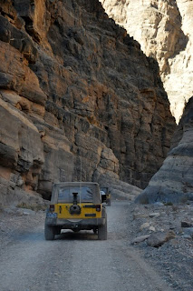
The canyon narrows to only 20 ft. and towers a few hundred feet above us
then widens out again
We exit into the valley
and stop along the roadside for lunch
We then head for Chloride Cliff. This is an area that was dotted with mine exploration. Silver ore was discovered in the early 1870s. The early miners had to go 250 miles to Barstow, CA for groceries. Eventually gold, silver, lead and cinnabar were found but the ore was mostly of low grade. Only the size of the veins made it feasible to mine. Production of the cinnabar was in excess of one million dollars.
One could keep busy exploring roads for an entire day as they cover the hillsides.
There are fabulous views into Death Valley. On clearer days one can see Mount Whitney 80 miles distant.
One last mine for the day.....
Sunset nears as we approach civilization once again